What is LiDAR? Everything You Need to Know
LiDAR stands for Light Detection and Ranging. It is a smart technology that helps in measuring distances using laser beams. The LiDAR system sends a laser light from a source & waits for it to bounce back after hitting an object
By measuring the time it takes to return, it calculates the exact distance.
Today, LiDAR technology is used to build 3D maps and is very helpful in self-driving cars, drones, mobile phones, and environmental studies. It gives accurate data for navigation and safety.
History of LiDAR
The LiDAR technology was developed in the 1960s and was mainly used for aviation & military purposes. Over time, it became advanced, faster, & more affordable.
In the 1990s, LiDAR sensors were used for mapping and environmental studies. Today, it is widely used for exact object detection and navigation in self-driving cars, autonomous vehicles, drones, and mobile phones.
How LiDAR Works?
LiDAR works by using laser light to measure distances accurately. Here’s how it works, step by step:
Scanning Mirrors
Some LiDAR systems use a scanning mirror or more than one laser beam to cover a large area. LiDAR technology gives very accurate distance readings. Hence, it is useful for solving many different problems.
Remote Sensing
In remote sensing, LiDAR systems can measure how light is scattered, absorbed, or sent out again by particles or gases in the air.
To do this, the LiDAR sensor may need to use a laser with a specific wavelength. It can help measure gases like methane in the atmosphere, or find out how many particles (aerosols) are in the air. It can also measure raindrops to tell how far away a storm is or how much it is raining.
3D Maps
Other LiDAR systems are used to create 3D maps of surfaces like land, roads, or buildings. In these cases, the laser beams don’t need to match any special wavelengths.
Instead, they are picked to be safe for the eyes or to avoid things in the air that might block the signal. The laser beam hits a hard object & reflects to the LiDAR receiver.
Doppler Technique
LiDAR can also measure how fast something is moving. This is done using the Doppler technique or by quickly measuring the distance again & again. For example, LiDAR systems can check the speed of wind or how fast a car is moving.
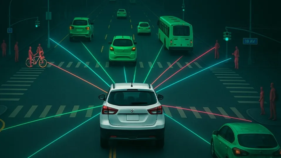
LiDAR technology is also used to make 3D images of scenes that change, like roads for self-driving cars. This is usually done by scanning the area around. These 3D models help vehicles see & understand their surroundings in real time.
What is the Use of LiDAR Sensor?
The use of LiDAR sensors goes far beyond vehicles. It is used for:
- Mapping surfaces (like ground or buildings).
- Creating 3D maps of forests or coastlines.
- Understanding weather patterns.
- Navigating robots & autonomous vehicles.
Whether for drones, satellites, or cars, LiDAR sensors provide accurate distance data quickly.
Components of a LiDAR System
A LiDAR system uses several key parts that work together to measure distances and build 3D images of the surroundings. These parts include a laser, scanner, detector, processing unit, & a navigation system like GPS and IMU.
Here’s a simple explanation of each component:-
- Laser Source
- This is the centre of the LiDAR system.
- It sends out light pulses, usually in the infrared range.
- These light pulses hit objects & bounce back, helping measure distances.
- Scanner
- The scanner moves or directs the laser beam across a wide area.
- It helps the system scan & collect data from different directions.
- There are different types of scanners, like:
- a) Mechanical scanners
- b) MEMS (Micro-Electro-Mechanical Systems) scanners
- c) Solid-state scanners
- Detector (Receiver)
- This part catches the light that comes back after hitting an object.
- It changes the reflected light into electrical signals for the system to understand
- Processing Unit
- It processes the data received from the detector.
- It calculates how far objects are & creates a 3D point cloud.
- The processor can be:
- a) A microcontroller
- b) A computer
- c) A specialised chip (ASIC)
Navigation System
This helps the LiDAR know where it is and how it’s moving.
- GNSS/GPS
- Gives exact location data.
- It helps tag the LiDAR data with real-world locations (georeferencing).
- IMU (Inertial Measurement Unit)
- Tracks the orientation (angle/tilt) & movement of the LiDAR.
- This ensures each point in the 3D model is correctly placed.
- GNSS/GPS
- Optics
- These include lenses, mirrors, & filters.
- They help focus the laser light & direct both the outgoing and incoming beams correctly
Types of LiDAR
There are mainly two types of LiDAR systems based on how and where they are used:
Airborne LiDAR
Airborne LiDAR technology is mounted on drones, helicopters, or aircraft. It scans land from the sky & helps create digital maps. It’s commonly used in forestry, flood mapping, and terrain study.
LiDAR sensors for drones are especially helpful in capturing high-resolution maps
Types of Airborne LiDAR include:
- Bathymetric LiDAR: Sends green laser beams to map underwater surfaces like the sea floor. It works better than infrared lasers in water
- Space-based LiDAR: Used by NASA & others to map planets, navigate space vehicles, and even fly helicopters on Mars like Ingenuity.
Terrestrial LiDAR
Terrestrial LiDAR is used on the ground to scan surrounding areas. It gives highly detailed & accurate data.
Types of terrestrial LiDAR include:
- Static LiDAR: Fixed in one place to scan the same area many times. Great for construction, archaeology, & monitoring hazards like floods or volcanoes.
- Mobile LiDAR: Placed on moving vehicles. It captures data in motion and is widely used in the automotive industry for smart features & autonomous driving.
Applications of LiDAR in Cars
Autonomous & Self-Driving Cars
- LiDAR for cars helps cars avoid crashes, stay in their lanes, & understand road conditions.
- It reads traffic signs & measures distance from other vehicles.
ADAS (Advanced Driver Assistance Systems)
LiDAR helps with:
- Lane departure warning
- Blind spot alerts
- Adaptive cruise control
These systems make driving safer and easier.
Benefits of LiDAR in Automotive & Self-Driving Cars
- Precision & Accuracy
- LiDAR technology works even in fog, rain, or dark conditions.
- It gives clear & sharp data for smooth and safe navigation.
- Enhanced Safety
- It scans the surroundings in real time.
- Detects vehicles, pedestrians, & obstacles with precision.
Future of LiDAR Technology in Cars
Here’s what to expect:-
- Self-Driving Cars (Level 4 & 5): LiDAR will be key in real-time 3D mapping and object detection.
- Better Safety: Faster reaction times and improved emergency braking systems.
- Smart Cruise Control: Smart Cruise Control speed based on traffic, curves, & slopes.
- Night Vision: Works in dark, foggy, and rainy conditions.
- Future Impact: Completely autonomous valet parking and self-parking features.
- Self-Parking: Cars will park themselves using LiDAR-powered parking assist.
- V2X Communication: Cars will talk to traffic signals and other vehicles for safer roads.
- Affordable LiDAR: Prices are coming down, and smaller LiDAR units will fit into more vehicles
- Solid-State LiDAR: This compact and cheaper version will become standard.
Challenges and What’s Next for LiDAR
Reducing Cost:
Right now, LiDAR is expensive. But as more & more LiDAR systems are made, the cost will go down. It will become cheaper for everyone to use.
Using AI with LiDAR:
LiDAR will work even better when it is used with Automotive Artificial Intelligence. This will help in spotting objects more accurately & making smarter decisions.
Rules and Safety:
Governments will have to make new rules & safety guidelines for using LiDAR in vehicles. These are especially great for driverless cars, to keep people safe.
LiDAR: A Key Technology for Safer Driving
LiDAR systems are revolutionising the way cars operate, making roads safer and paving the way for fully autonomous driving. As this technology continues to evolve, we can expect smarter, safer, & more efficient transportation shortly.
The future of driving is here & LiDAR is leading the way!